2007 Ancient Merv Project: High Definition Documentation
October 27, 2007
I have just returned from Turkmenistan after a six-week collaboration with the Ancient Merv Project for its 2007 field season. The ongoing project by the Institute of Archaeology (IoA) at University College London (UCL) is in collaboration with the State Historical and Cultural Park Ancient Merv and this year expanded its collaboration to include the professional UK surveying firm Plowman Craven and Associates (PCA) and CyArk. The project’s goal was to document the mud brick structures of Merv, Turkmenistan for conservation studies and planning.
For six weeks a small team consisting of myself and Joseph Severn of PCA conducted the HDD project where eight of the site’s monuments and two excavation trench section were fully documented with terrestrial 3D laser scanners (with the use of a Leica Scan Station) and HDR photography.
Merv is a UNESCO World Heritage Site and is unique in its archaeological resources. The site consists of a historically important city along the Silk Route across Central Asia from China. For two and half millennia the city cycled through phases of power and wealth, but was always strategic along the Silk Route. To add to the archaeological uniqueness, the city was expanded and rebuilt but never over itself. It began with the inner city of Gyaur Kala, which later became the citadel for Erk Kala when Alexander the Great sent a representative to ‘conquer’ the city. Later, when the Islamic army arrived, they moved the city next door (possibly to improve water supplies) and built Sultan Kala. In the 15th century the Timurids again moved the city further south. The result is immaculate archaeology just below the surface with little disruption or disturbance–or in the case of this particular documentation project, structures still standing above ground!
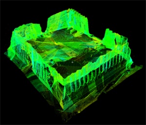
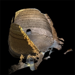
Below is a silhouetted view of the point cloud for the Greater Kyz Kala (the largest still-standing structure on the site which resides just outside the Islamic city’s defensive walls. The Greater Kyz Kala’s exact function and use is unknown, but some expect it to have been a semi-fortified noble house. Whatever it was, it would have been at least 2, although likely 3, stories tall with no ground-level entrance and vaulted-ceiling rooms surrounding a central court yard. Beneath the Greater Kyz Kala is an example of a photo-textured point cloud where I have used a 360-degree, spherical HDR panorama to texture the interior scans of an ice house.
There are several more structures that were not documented due to time-constraints, but it is hopeful that another collaboration will provide the necessary resources to finish documenting the most endangered structures at Merv before further significant erosion can take place.
For six weeks a small team consisting of myself and Joseph Severn of PCA conducted the HDD project where eight of the site’s monuments and two excavation trench section were fully documented with terrestrial 3D laser scanners (with the use of a Leica Scan Station) and HDR photography.
Merv is a UNESCO World Heritage Site and is unique in its archaeological resources. The site consists of a historically important city along the Silk Route across Central Asia from China. For two and half millennia the city cycled through phases of power and wealth, but was always strategic along the Silk Route. To add to the archaeological uniqueness, the city was expanded and rebuilt but never over itself. It began with the inner city of Gyaur Kala, which later became the citadel for Erk Kala when Alexander the Great sent a representative to ‘conquer’ the city. Later, when the Islamic army arrived, they moved the city next door (possibly to improve water supplies) and built Sultan Kala. In the 15th century the Timurids again moved the city further south. The result is immaculate archaeology just below the surface with little disruption or disturbance–or in the case of this particular documentation project, structures still standing above ground!
Below is a silhouetted view of the point cloud for the Greater Kyz Kala (the largest still-standing structure on the site which resides just outside the Islamic city’s defensive walls. The Greater Kyz Kala’s exact function and use is unknown, but some expect it to have been a semi-fortified noble house. Whatever it was, it would have been at least 2, although likely 3, stories tall with no ground-level entrance and vaulted-ceiling rooms surrounding a central court yard. Beneath the Greater Kyz Kala is an example of a photo-textured point cloud where I have used a 360-degree, spherical HDR panorama to texture the interior scans of an ice house.
There are several more structures that were not documented due to time-constraints, but it is hopeful that another collaboration will provide the necessary resources to finish documenting the most endangered structures at Merv before further significant erosion can take place.