3DReshaper helps CyArk create impressive 3D models of Cultural Heritage icons
CyArk is proud to announce a signed MOU with 3DReshaper
March 28, 2012
In a continued effort to bring the best tools for digital preservation to our workflow, CyArk has finalized an MOU with Technodigit, the makers of 3DReshaper meshing software. CyArk began testing the software on select projects in 2011 and its power and robust ability to create clean, accurate meshes easily from laser scan data has brought it into our regular workflow for data processing and deliverables creation.
CyArk is pleased to list Technodigt (part of Hexagon Group) as one of its Contributing Partners for their donation of software to help CyArk pursue its mission of digital preservation of the world's cultural heritage sites.
We utilize the software to make detailed 3D models of intricate details such as the serpent heads of the Pyramid of Quetzalcoatl at Teotihuacan, Mexico (see RIGHT, Top). Or take advantage of the easy extrapolation of contour lines to create digital terrain models critical for site conservation efforts like those at the ancient site of Sivu'ovi in Petrified Forest National Park, which resides on a bluff and is suffering catastrophic erosion (see RIGHT, Bottom).
Pascal Lefebvre-Albaret, founder of Technodigit, adds "When I created the 3DReshaper software, one of the first applications was to make a copy of the famous Lascaux prehistoric cave in France, which no longer allows visitors due to fungal proliferation on the walls. Through this new partnership with CyArk, the entire Technodigit team is extremely proud that our software can help to preserve humanity's important cultural heritage. Every day we develop 3DReshaper to create accurate and realistic models. We are very pleased that our technology is used to render tools that allow virtual access for a very large public audience to ancient monuments of past civilizations, and can help to preserve the world's heritage. Congratulations to CyArk for this great work!"
If you're not on the list, sign up for CyArk's Newsletter to hear of new project releases that will include these wonderful 3D models, terrain maps, and more: http://archive.cyark.org/register
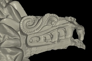
Mesh of the serpent head of Quetzalcoatl at Teotihuacan, created in 3DReshaper.
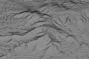
The bluff of Sivu'ovi is modeled as a mesh from the terrestrial LiDAR and a contour map is created. The contour map can then be used for hydrological survey to monitor water-based erosion.