Global Warming’s Effect on Heritage Sites
August 15, 2007
CyArk announces its newest feature, a fully interactive Hazard Map showing inundation levels and plotting previously recorded earthquakes. Everyday, global warming is becoming more and more of a reality and one of the many consequences of this is glacial melt which is slowly but surely raising the current sea level. There are many heritage sites close to the ocean at low elevations in danger of rising sea levels. Along with the dangers of other natural disasters (earthquakes, fires, etc), we are running out of time to document many of these sites. This new map shows exactly what parts of the planet will be underwater at a given sea level rise, and which sites are going to be effected. Please see the FAQ for instruction on use of the Hazard Map.
This edition of the CyArk Hazard Map is a beta, and we are looking to improve and add to it’s functionality. We intend to overlay other risks on our map such as fire danger due to climate change, armed conflicts, development, unregulated tourism, looting and inadequate security. However we have not yet located such information. If you have access to any type of data that could potentially be integrated in the Hazard Map, or can direct us toward such data, please contact us. Please note that future additions (including increasing the max zoom from 5 levels to 9 and adding customizable “My Places”) are being planned for the future. Subsequent articles will be written to detail these so stay tuned for future updates!
As we have just released this, we would welcome any input, suggestions, feature requests, or bug reports. Please add a comment below addressing your thoughts and we will attend to it shortly. (If your comments pertain to a particular view of the world, please click the Link To Page at the bottom and provide the url)
Most importantly, please enjoy our Hazard Map!
Landon Silla
Manager of Information and Technology
UPDATE (8-20-07): We have just added an additional zoom level increasing the total zoom to six levels.
UPDATE (1-18-08): We have just added an additional THREE zoom level increasing the total zoom to nine levels.
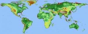
CyArk Hazard Map showing 25 meter inundation level